Definitions & Methods
Introduction
The Water Conflict Chronology was developed and has been maintained by the Pacific Institute for over three decades. Additions, modifications, and updates to the Chronology are posted periodically, with major revisions in 2018, 2019, 2022, and 2023. In 2024, more than 300 new entries were added to the database including events through the end of 2023. The methods described below refer to the process used for these updates. Additions to the database are enabled by reviewing and integrating information from media reports, conflict studies, and free, publicly available databases that track violence and conflict around the world. The databases that were used are listed in the Sources section below.
Basis or Form of Conflict Update
Each entry is categorized on the basis of the form of conflict. Some entries involve more than one form of conflict.
- “Trigger:” Water as a trigger or root cause of conflict, or underlying cause of ongoing tension that is contributing to conflict, where there is a dispute over the control of water or water systems, or where economic or physical access to water, or scarcity of water, triggers violence.
- “Weapon:” Water as a weapon of conflict, where water resources, or water systems themselves, are used as a tool or weapon in a violent conflict.
- “Casualty:” Water resources or water systems as a casualty of conflict, where water resources, or water systems, are intentional or incidental casualties or targets of violence.
Country
The country assigned to each event most commonly indicates the location of the event. When the event is a threat (rather than a physical occurrence), then the country listed is the location of where the water resource or water system that is threatened exists. However, there are some instances where these rules do not apply and/or two or more countries are listed. Two or more countries may be listed if the event occurs in two or more places, or, if the event is in a disputed region. Finally, if the event occurs in one country but actors from multiple countries are involved, all countries involved are mentioned in the description.
Regions
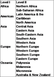
All entries in the Water and Conflict Chronology have been categorized by world region using the United Nations (UN) Geographic Regions(https://unstats.un.org/unsd/methodology/m49/, accessed 4/17/2018). The UN regions are based on Continental Region (Level I); which are further subdivided into Sub-Regions (Level II) and Intermediary Regions (Level III). We categorize entries by the Level II Sub-Regions. Level I and Level II are presented in the table below.
Violence Designation
Previous versions of the Water and Conflict Chronology categorized each entry as violent (“Yes”) or non-violent (“No”). For the 2018 and later updates, we updated the criteria for including items in the Chronology:
Items are now included when there is violence (causing injuries or deaths) or threats of violence (including verbal threats, military maneuvers, and shows of force). We do not include instances of unintentional or incidental adverse impacts on populations or communities that occur associated with water management decisions, such as populations displaced by dam construction or impacts of extreme events such as flooding or droughts. A growing number of protests are being reported worldwide over the lack of local access to safe water and sanitation. We include these only when there are reports of injuries, deaths, or direct attacks on water systems.
Lumping & Splitting
Events were “lumped” into a single entry, if the timing, event description, parties involved, and geographic location were sufficiently close in time to indicate that it was highly likely that they were either the same event or sufficiently connected to be part of a related action. Events close in time but reported in different locations or reported as different kinds of actions are included as separate entries.
Map Location
To map the entries, we gathered the latitude and longitude of each event using the location provided in the source of the entry. When a single entry contained an event or multiple events that occurred in more than one location, a more broad, generalized location was chosen to represent the entry. For example, if a single entry included an event in two cities in Yemen, then the centroid of Yemen was used to identify the latitude and longitude. If a precise location of an event reported in the source could not be identified, a more generalized location was chosen to represent the entry. Google Earth Pro is used for identifying event locations. Latitude and Longitude are recorded in decimal degrees format.
While we strive to provide comprehensive information, we are not able to guarantee that the placement of the event locations on our map are accurate. In some cases, exact locations are unknown or not reported, or are lost or misinterpreted in translation. Furthermore, many locally used place names are not captured by geographic information systems such as Google Earth Pro, and/or by the western, English-speaking community in which this chronology was created.
Sources
A “source” for additional information or background is provided for each entry. For the 2018 Water Conflict Chronology update, Internet searchers using terms such as “conflict database” and “war database” were used to discover online repositories of violent conflict events that were related to or involved fresh water. These searches revealed several new sources of potential entries for the Chronology. The list of sources identified as useful for providing new entries for the Chronology is below, including web URLs and the date of the last download from the associated source.
The list below should not be taken as a comprehensive or all-inclusive list of all possible outside sources for finding water-related conflict events. We will continue to add to this list as we discover new sources that can provide this kind of information.
Of note, the Princeton University Library maintains a Politics Resources Guide, which is an annotated guide to other online resources and data sets. It includes a sub-section on conflict and security resources. Note that all sources from the Princeton University Library website that were categorized under “Conflict, Political Violence, and Peace Data” were investigated for opportunities to extract water-related violent events. Only those sources listed below were found to be searchable for these types of events. As always, we welcome contributions of additional information and data, corrections, or questions at info@pacinst.org.
Armed Conflict Location and Events Dataset (ACLED)
https://www.acleddata.com/
Date of most recent download: 6/28/2024
Citation: Raleigh, Clionadh, Andrew Linke, Havard Hegre and Joakim Karlsen. 2010. “Introducing ACLED-Armed Conflict Location and Event Data.” Journal of Peace Research. 47(5) 651-660. Data Exported June 28, 2024. https://www.acleddata.com/data/.
UCDP/PRIO Armed Conflict Datasets
http://ucdp.uu.se/downloads/
Date of most recent download: 1/11/2022
Dataset Names: UCDP Georeferenced Event Dataset (GED) Global version 21.1; ACLED Global version 17.2 (2016)
Citation 1: Pettersson, Therese, Shawn Davis, Amber Deniz, Garoun Engström, Nanar Hawach, Stina Högbladh, Margareta Sollenberg & Magnus Öberg. 2021. “Organized violence 1989-2020, with a special emphasis on Syria.” Journal of Peace Research. 58(4).
Citation 2: Sundberg, Ralph, and Erik Melander. 2013. “Introducing the UCDP Georeferenced Event Dataset.” Journal of Peace Research. 50(4) 523-532.
Citation 3: Croicu, Mihai and Ralph Sundberg. 2017. “UCDP GED Codebook version 17.2.” Department of Peace and Conflict Research, Uppsala University.
Global Terrorism Database (GTD)
https://www.start.umd.edu/gtd/
Date of most recent download: 3/3/2022
Citation: National Consortium for the Study of Terrorism and Responses to Terrorism (START). (2019). Global Terrorism Database. Retrieved from https://www.start.umd.edu/gtd.
Yemen Data Project
https://yemendataproject.org/data.html
Date of most recent download: 3/3/2022
Citation: Yemen Data Project. No Date. Airwar dataset. https://yemendataproject.org/data.html. Accessed March 3, 2022.
Social Conflict Analysis Database (SCAD)
https://www.strausscenter.org/scad.html
Date of most recent download: 2/2/2018
Citation: Cullen S. Hendrix and Idean Salehyan. 2018. “Social Conflict Analysis Database (SCAD).” www.scaddata.org. Accessed February 2, 2018.
Issue Correlates of War
http://www.paulhensel.org/icow.html
Date of most recent download: 2/2/2018
Citation: Paul R. Hensel, Sara McLaughlin Mitchell, Thomas E. Sowers II, and Clayton L. Thyne (2008), “Bones of Contention: Comparing Territorial, Maritime, and River Issues.” Journal of Conflict Resolution 52, 1 (February): 117-143.
RAND Database of Worldwide Terrorism Incidents
https://www.rand.org/nsrd/projects/terrorism-incidents.html
Date of the most recent download: 2/6/2018
Citation: RAND Database of Worldwide Terrorism Incidents. https://www.rand.org/nsrd/projects/terrorism-incidents.html. Accessed on February 6, 2018.
Other sources that have yet to be investigated for potential water-related conflict entries include:
- Data Development for International Research (DDIR) – Inter-University Consortium for Political and Social Research (ICPSR)
- International Crisis Behavior Project
- Conflict and Peace Data Bank
- Global Event Data Systems
- Foreign Broadcast Information Services (A US CIA database)
- World News Connection
- Lexis-Nexis
- Centro Nacional De Memoria Historica